An afternoon leisurely drive from Milton Keynes to 3 or 4 great little roads nearby. Sure, it’s not the Welsh mountains but hopefully a couple of fun little roads. Please stay safe.
The Mission: Have an enjoyable afternoon drive, whilst keeping an eye out for rubbish on our route, if we see anything pull over (if it’s safe to do so) and collect it.
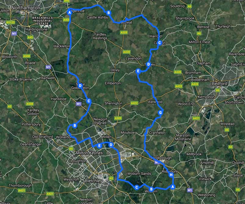
- The Google Map – This gives the full route plan. If this opens within the Google Maps app or doesn’t show the whole route it hasn’t worked, try loading in an incognito window. From this map you can click each waypoint and navigate to it via Google Maps and GPS.
- The TOGUK EarthDay Challenges
How best to navigate?
Follow the car in front is probably the best advice but if you get lost follow the instructions on this Google Map or use the location points inside the Tesla satnav listed below (or click the start/end points and then share these locations to your car via the Tesla app).
Are we using Glympse? Yes use the tag !TOGUKMK
I’m lost? Aim for the next stop on the map and ring 07712763305 so we can pull over and wait for you.
Part 1 arrive at 11am
Start: Campbell Park – Car Park
Haversham
Gayhurst
Stoke Goldington
Horton
End: 52.238826, -0.803768
Part 2
Start: 52.238826, -0.803768
Manor Road, Grendon
Carlton, Bedford
Turvey
Hardmead road, MK43 8AE, UK (Nr Newton Blossomville)
The Old Swan at Astwood (Possible Stop Point, if car park looks empty)
Cranfield University (Possible Stopping Spot, if an obvious open car park, there is a Budgens here)
Salford, Bedford
Ridgmont
End: 51.993731, -0.572168
Part 3
Start: 51.993731, -0.572168
Woburn Deer Park – Be very careful of deer in the road! Feel free to stop or go very slow whilst going down this road
Woburn
Longslade Lane Car Park, Aspley Heath, Milton Keynes (Possible Stopping Spot if we’ve not stopped anywhere else on route)
Bow Brickhill
Tongwell Street, Milton Keynes
End (back to the start) Campbell Park – Car Park